Intro: If you wonder about the choice of route, phase and schedule, please read more about the 'How?' on the 'Home'-page.
As we progress, we are adding 'trail-pictures' and diaries with stories and our travel experience.
As we progress, we are adding 'trail-pictures' and diaries with stories and our travel experience.
|
June 3rd
We are ready to start our big adventure. Today we have completed the last preparations for tomorrow's start in Astoria OR. |
|


Astoria OR - Coburg OR
Diary
June 4th, Astoria-Rockaway: It was a beautiful but very windy ride south along the Oregon coast. The equipment and our legs are in good shape! They mastered almost 100km and 1000 meters+ in elevation change. June 5th, Rockaway-Pacific City: Another windy day to Pacific City. It was sometimes difficult to stay in our lane. But short enough to have a last look at the Pacific before we start riding East tomorrow. June 6th, Pacific City-Monmouth: On a very hot (32C/90F) day, we navigated the traffic and also climbed some steep hills. We are slowly getting used to life on the road. Now we are cooling down with a few cold beverages. June 7th, Monmouth-Coburg: Yesterday and today it was pretty warm and sunny as we rode inland to Coburg. We missed the ocean breeze and we also learned that a great breakfast is essential to start the day. We also realized how rural and beautiful - open fields, rivers, groups of trees- this part of Oregon is. Tonight we stay at a campground for the first time on our journey. We managed to set up the tent and run the burner! So all is well with these pieces of equipment as well. |

|


McKenzie River
Then on to Sisters:

Smith Rock Park

Beautiful public park near John Day
|
Coburg OR - Baker City OR
Through the Cascade Range
Stage 2 has a couple of challenges in store. It leads us inland, along the McKenzie River, through the Cascade Range and close to the famous Three Sisters. The Three Sisters form the center of a region of closely grouped volcanic peaks. We will be taking the Santiam Alternate (Santiam Pass) instead of the McKenzie Pass. Snow usually keeps McKenzie pass closed until early July, though it may be open to cyclists 2-4 weeks prior. We will be oscillating between 3000-5000' and the stage has five additional passes in store for us before we reach Baker City, close to the eastern border of Oregon. (Distance: 348 miles / 559km; Elevation: 13361' / 4072m) 
June 8th, Coburg-Belknap Springs: The McKenzie river was a constant presence during our ride to McKenzie Bridge today. It flows down from the cascade mountains while we are working our way up. Friday is our first scheduled off day. So we are staying at a small hotel in Belknap. As we rode up to the building we noticed an older lady planting lots and lots of beautiful flowers around the entrance and the parking area. We approached her later to tell her that she was doing a wonderful job. We chatted a bit, until she explained with a smile that she also had a secret garden, hidden in the forest close to the hotel, where few people find it. We certainly did not expect what we found! A walled area with ponds, walls, lights and lots of flowers! Amazing! (see the pictures on the left) June 10th, Belknap Springs - Sisters: Today's ride led us up the Cascades, through the forest, across Santiam pass (4817 feet) to Sisters. We stopped at Fish Lake, a lake that was created by lava 3000 years ago and completely disappears in summer after the melted snow is gone. The fish retreat into a nearby creek and return again when the winter's snow is melting again. Our route essentially circled around Mt. Washington (7794 feet). It looks like a mountain a child would draw... the same from multiple angles. Most of the mountains in that area are of volcanic origin, and there are still a lot of areas where the lava has cooled and is visible as lava streams. June 11th, Sisters - Prineville: Today's ride to Prineville was meant to be somewhat easier than the previous one. But then of course we took the scenic route ( which is always longer...) and it turned out to be another very warm day without much shade. The area reminded us of Southern Colorado, with it's dry vegetation, sagebrush, open fields, and mountains in the background. We stopped at the Smith Rock Park, a mekka for climbers and of course another detour... June 12th, Prineville - Mitchell: Special day (Rolf's birthday) and a beautiful setting. All morning, we climbed through a lush valley with virtually no civilization (except for the street, of course 😉) to Ochoco Pass. 50 km of relatively steady climb. With a steep drop into Bridge Creek Valley and another steep hill up to Mitchell where we camped for the night. Mitchell is a small tourist place (pop. 150) close to the Painted Hills rock formation. A general store, a nice and well maintained park, an antiques place, and a fabulous little micro brewery (great choice!) with restaurant. June 13th, Mitchell - Dayville: We got up early (6 am) to use the fresh start of a day that promised to be warm (~90° F) again. After a very steep and quickly warming climb, we enjoyed rolling downhill through the open, very rural countryside. Only to dive into a narrow gorge of dark Basaltic rock, an obvious testimony of the volcanic history of Oregon 🌋. We finally found a quiet little place in Dayville OR, a warm shower and a clean bed. June 14th, Dayville - John Day June 15th, John Day - Bates, Austin Junction June 16th, Bates Austin Junction - Baker City: We arrived in Baker City, OR. We were 'off the grid' (no Internet access) for a few days as we rode through Eastern Oregon, climbed a number of passes, camped out in some beautiful places, and met many interesting people. Yes, it is still Oregon, but except for the license plates, everything seems different. The pace has slowed down to a point where even the waitress waits to bring more food, while a family prays at the table. The scenery remains beautiful throughout but gets increasingly rugged. We learned more about the history of a small town of Bates, which no longer exists and was closely linked to the ups and downs of the logging industry, like many things in this part of Oregon. While this is a very exciting journey, we also realized today that we really need a day off... In Baker City, we are going to have a one day break for our body and our minds before we move on. |


Baker City OR - Missoula MT
Retracing Lewis and Clark
Stage 3 traces part of the Lewis and Clark expedition - backwards. Through the land of the Nez Perce with its famous Chief Joseph and along the Bitterroot River. At this stage we leave Oregon, briefly cross the state of Idaho before we enter Montana. It is a long stage of 7 days. The 'pièce de résistance' are numerous little passes and hills that can wear you down, and before you reach Missoula, you have to cross the Lolo Pass at 5235'. This is also the stage where the population density is very low, there are few accomodations and where our camping gear will certainly get very 'good usage'. (Distance: 419 miles / 674km; Elevation: 14121' / 4304m) 
June 18th, Baker City - Halfway: What a cold and windy (50 mph gusts) day! We made it to Halfway (halfway between the town of Carson and Pine we were told), and we made it through the local bar, where we were invited to sit with some locals. We also had our first technical malfunction, as Rolf lost a bolt from his cleats... and he realized it, when he could not detach from his pedal. It will be difficult to replace it until we get to Missoula, so he has to tighten the remaining bolt every 15km or so... Still an interesting day through a very different countryside without trees but with lots of open range cattle. June 19th, Halfway, OR - Cambridge, ID: We crossed our first state border! We finally made it to Idaho (Cambridge ID, to be exact, after another 1100m elevation and 90km). And we had another argument with the weather. 36°F / 1.5°C and drizzle when we started, dry conditions around noon, a heavy hail storm early afternoon that forced us to find protection under a tree to be followed by a thunderstorm, rain and wind before we reached our destination! Fortunately we had planned to stay in a hotel with heating and a hot shower and not in our tent! We rode in a valley called Hells Canyon, which is normally known for its heat. The Snake River running through the valley is dammed multiple times to create lakes for boating and hydroelectric plants. It might not be as open and pretty, but it was definitely interesting. June 20th, Cambridge - New Meadows: We are in a heavily wooded area again riding between 3000 and 4500 feet. A lot of logging industry with saw mills and piles of freshly cut wood. It's no longer dry brush like in Baker City but there are lots of creeks and meadows along our route. It's sometimes difficult to keep track of what creek we are following. June 21st, New Meadows - White Bird: We made it to White Bird (104km). Red's kitchen and a general store, population 91! Small but beautifully located next to the Salmon River. no Salmon on the menu though 😁 just Cheese Melt, BLT, a 🍔 and some salad! White Bird is named after a Nez Perce chief. This was all Nez Perce land. Today, the actual reservation is much smaller, to the North of White Bird. Today was pretty tough starting at freezing temperature in the fog. So, we decided that the 22nd is a good day to take off, a day earlier than planned, but well deserved! June 23rd, White Bird - Kooskia/Syringa: We had a great day off yesterday. We relaxed, went to the Salmon River Beach, and had a great time meeting 'neighbors' (a large group from Mt. Vernon WA). Their salmon and cabbage were as delicious as the homemade Bourbon we had for dessert 😋. They were convinced that the Bourbon was the right fuel to go up White Bird Hill the next day! This morning, we took the Old US95 up the hill... lots of switchbacks but very little traffic! So we were able to chat most of the almost 1000m up the hill and on to Grangeville, where we stopped for food and camping burner fuel that we need, starting tomorrow. Tonight, we are at a lovely B&B between Kooskia (the a is not pronounced) and Syringa, right next to the Clearwater River. June 24th-26th, Kooskia/Syringa ID -Missoula MT: We made it to Missoula. Halfway from Astoria to Beulah! We followed the Clearwater, the Lochsa, the West Fork Lolo Creek, the Bitterroot River to the Clark Fork River. Lots of rivers and trees, absolutely no cell phone reception or Internet for days. The Selway-Bitterroot Wilderness is the home of the Nez Perce, squirrels, fish, moose, etc. but not much civilization. Lewis and Clark explored this region in 1804/5. But we did not just meet squirrels, we also met some great people! Among them Dorrie and Mike Williams. They invited us for dinner at a 'wild' camp site, and we spent an interesting evening. They had crossed the US on a three person bike with their 9 year old son in 2009! It was fun to exchange bike stories and views on how to handle the challenges of life. We have a day off tomorrow. After 1600km we will also get a tune-up for our bikes at Bike Works ( a local bike shop). A new rear tire and a new chain for Rolf's bike. Pulling the 65 pound trailer has been tough on the wear of both (probably all 3🤪). |

Open country on the way to Halfway, OR
Crossing the first state line
Over Meadows to New Meadows

Grangeville High Plateau just north of the White Bird Hill.
Through Idaho Wilderness to Missoula, MT
|


Idyllic campsite at Indian Trees Campsite
Heading out from Missoula
Virginia City, one of several old gold mining towns

Earthquake Lake

Yellowstone tour (Upper Yellowstone River Falls)
|
Missoula MT - West Yellowstone MT
To the Gates of Yellowstone
Stage 4 continues on the Lewis and Clark route backwards and close to historically important battlefields of the Nez Perce war, where they fought for self-determination in 1877. They refused to settle in the reservation that had been assigned to them and they tried to flee to Canada. The U.S. Army went after them, caught them shortly before they reached the border and forced them back. One of the many passes we cross is the Chief Joseph Pass. We will always stay on the main route until we reach West Yellowstone, our gate to the wonders of Yellowstone National Park. (Distance: 330 miles / 531km; Elevation: 12853' / 3918m) 
..
June 28th, Missoula - Hamilton: We left Missoula in the pouring rain south to Hamilton. We spent our off day in Missoula. This city is certainly not what one would expect in Montana. Pride flags all over and pictures of the transgender state representative Zooey Zephyr, lots of Marijuana stores, small coffee places full of students on their notebooks, art galleries, vinyl records stores, surfers on their boards in the river, etc... and all in an otherwise relatively conservative state; no wonder its nickname is Zootown 🤣. Missoula also hosts the headquarters of the Adventure Cycling Association, where our maps and our GPS data were generated. They do a great job promoting cycling throughout the US. We visited their offices on our day off and got ice cream and our picture taken. They also weighed our trailer, which is now officially 74.7 pounds. Missoula also has multiple bike shops. We went to Bicycle Works, got a complete check, a cleaning, new chains, and a new tire in a few hours. Thanks Alex! June 29th-30th, Hamilton - Jackson: It is the last day of June, and we made it to Jackson Montana, population 39. We are really glad, we found a place to sleep and rest. Again, we have been without any kind of electronic communication for a couple of days and camping. There is no or very little grocery shopping or restaurants in this area and so meal planning becomes a real task with the limited space we have for food. However it is a remote but excitingly beautiful area of Montana. It's is known for the Nez Perce war and the flight of the Nez Perce from the US Cavalry over hundreds of miles and a hide and seek between the Nez Perce and the authorities over a period of over 4 months. We crossed the Chief Joseph pass at over 2200 meter, where he had led his people into Big Hole Valley. Today we visited the Big Hole National Battlefield where many Nez Perce and soldiers lost their lives, only a few weeks after the famous Battle at Little Big Horn (300 miles away) and General Custer. Big Hole is not as famous but it was absolutely devastating for the Nez Perce. We have reached 1825 km and 14820 meters ascent! Obviously our personal record for a month. July 1st, Jackson - Dillon: All day, we traveled through an even more remote area than up to now: grassland and sagebrush valleys between snowcapped mountains, without any farms or villages! It was beautiful! As we were getting close to Dillon, a heavy storm caught up with us. The wind gusts would push the trailer off to the side off the street, and riding the bike was not possible anymore. We stopped and sought shelter behind the first building we found until the storm was over. Later, we found out that this very storm had knocked out the power line for half the city! It sent us right back into the last century: The hotel couldn't complete our check-in because the computers, the credit card, the key cards, etc. didn't work. All restaurants in town, traffic lights, and so on didn't either. We had traveled through an area almost untouched by technology (no cell phone), and even in town, we were still in the 19th century. Well, we were back in the 21st century around 8 pm, and everyone, including us, was pretty relieved that things we are used to started working again. July 2nd, Dillon - Virginia City: Today, we traveled through gold mining history and reached Virginia City, where we are staying in a refurbished miners cabin. We stopped at many of the historical panels along the road, either because we think that they are interesting or sometimes because we need a break. There was a lot of mining in this region, predominantly for gold. Our road followed the former gold transportation route and were glad that the band of robbers were already caught more than 150 years ago! 🫣 Most of them were actually in law enforcement, but it obviously didn't pay that well. On the way, we saw miles of gravel piles, where they used hydrolic dretching machines until 1930. Even to this day, the vegetation has a hard time claiming back the river beds and hills. July 3rd, Virginia City - Madison River Resort: We are getting closer to Yellowstone National Park. We are definetely getting higher up, and the mountains around us are 3000 meter high and even higher. We are also now encountering bikers cycling in the other direction, who left in early May. They have scary stories about the Ozarks or tell us about great places to visit. We hear comments like: "oh, you just started" while it doesn't feel like that at all! It has been a month on the road! We also decided to glamp to day and not to camp. It is rainy and very windy. The tent we rented at the campground has furs (not real) and a heater! So while the storm is raging outside, we are cozy inside and write this report 🤗 July 4th, Madison River Resort - West Yellowstone: It is the 4th of July. Independence day! On the road it feels like all 335 million are heading somewhere, and at least half seems to be heading to Yellowstone, where we are also heading. It's ok to ride on the shoulder, but the person who invented rumble strips AND put them on the shoulder should be shot on the spot! When there are rumble strips we usually have 6 to18 inches to ride, which is a real task with a trailer and winds coming from all sides. It also spells real danger to even touch the rumble strip with a loaded bike. There was no strip but a real rumble on August 17th 1959. That day there was a 7.4 earthquake (the largest in Rocky Mountain recorded history) close to the Yellowstone park that caused a 34 million cubic yard rock slide along the Madison River, and generated a huge plug across the valley. Immediately the river was dammed, flooded cabins and campgrounds along the river, killing 28 people. Hundreds where eventually evacuated, a spillway was dug as quickly as possible, to keep the lake from becoming too big and dangerous for the communities downstream, but that slide created what is today know as Earthquake Lake. We are now at a campground west of West Yellowstone, we have two days off from cycling.The 5th is a real break day with laundry, relaxation and pool, and on the 6th we go on a tour of Yellowstone Park. The park is simply too big to explore by bicycle. July 6th, West Yellowstone Tour (no cycling): We went on a bus tour through parts of Yellowstone today. Still a day off from cycling, and Yellowstone is just too big to explore by bike. Many years after the last visit, we again enjoyed the uniqueness of the first National Park in the US, dedicated in 1872. It is still an active Caldera, and more than 50% of all geysers worldwide are in Yellowstone! It bubbles, hisses, and steams all over the park. It is also the home to grizzlies, bison, wolves, and many other wild animals who survive the strong winters, also thanks to the warm water that keeps a few rivers from completely freezing over. Unfortunately, it is also the place where each year a few tourists get injured, because they want to take the perfect bison selfie... |


West Yellowstone MT - Rawlings WY

|
South along the Continental Divide
Stage 5 leads us through Yellowstone National Park, past the grand Teton National Park and mostly south along the Continental Divide, which we will cross numerous times. We already visited Yellowstone with the family about 20 years age, were awstruck by its beauty. So we will mostly likely take a couple of days to rest and enjoy its wonders again. The only major pass on this stage ist the Togwotee Pass at 9658'. The wild and open area around the Wyoming basin for many years 'belonged' to buffaloes, trappers and fur traders until gold was discoverd near South Pass in 1867. This not only brought fortune seekers, the railroad that was built also brough settlers. The buffaloes were decimated to a few thousands and the settlers started grazing their cattle. Only in 1890 Wyoming was the 44th state to join the United States. (Distance: 364 miles / 585km; Elevation: 12447' / 3794m) 
July 7th-8th, West Yellowstone, MT - Togwotee Mountain Lodge, WY: After a couple of days off at West Yellowstone, we had two long days of cycling. On July 7th, we left really early to get a head start of the big tourist traffic and our 105 km ride towards the south end of the park. We made it safely past the road construction ( no shoulder, rough roads, impatient drivers, etc.), friendly bison, and we luckily bypassed a thunderstorm and arrived at the Lewis Lake camping (no cellphone reception or wifi), where the mosquitos tried to eat us. But a smokey campfire helped to keep them at bay. Today, July 8th, we finally left Yellowstone. Right after the south gate, we got to see another highlight of the region, the Great Tetons and after 80km, towards the end of our ride, we climbed two thirds up the Togwotee Pass (2943 meter above sea level). We watched and enjoyed the flowers in all colors, and how they changed as we climbed higher. It was definetely one of the most exhausting rides up to now! But after a warm shower (there was none at the NPS campground yesterday), a good meal, and a good night's sleep on a soft bed, we should be ready for the next ride tomorrow. July 9th-10th, Togwotee Mountain Lodge - Lander: We are now in Lander, Wyoming. We finished climbing Togwotee Pass at 2943m, found a beautiful little lake at the top, and we enjoyed the views and our ride down to Dubois. On the 10th, we realized how open the Wyoming landscape is. For our Swiss friends: Wyoming has a population of about 580'000 and is more than double! the size of Switzerland. A lot of open space! Today we also got into a heated discussion with a traffic guide. They were resurfacing about 5km of the road. She stopped us and told us we had to wait for the pilot car to carry us to the end of the construction area. It would be too dangerous to ride behind the pilot car like a normal passenger car. When the pilot car finally came (a pick-up truck), they realized that its bed was full of stuff, so there was no room for two bikes and a trailer. We had to wait another 20 minutes for another pick-up truck. We were ready to ride through the construction area like we had at several sites at Yellowstone. We had left early to be at Lander before the hottest time of the day, just to waste an hour at a construction site, because they didn't know what to do with us 😠. Rolf ended up balancing two bikes and a trailer standing on the bed of the truck, while Cornelia was in the cabin, so much for safety 🙄! July 11th, Sink Canyon excursion: Today is a day off, but of course, we didn't completely stay away from the bikes. We took a short trip to Sink Canyon. Sink Canyon is known for its wildlife and for its 'disappearing' river. The Popo Agie River at one point disappears in the ground next to a cliff and naturally reappears from the ground after about 400 meters. Researchers have used artificial dye to find out what happens in between but just found out that it takes about 2 hours for the water to flow between disappearing and reappearing. It must fight its way through fissures in the limestone. But are there caverns or detours? Nobody knows just yet. In the afternoon it is shopping time for groceries. We won't see a lot of stores for the next 200km when we leave tomorrow. July 12th, Lander - Jeffrey City July 13th, Jeffrey City - Rawlins Did you know that there are more Pronghorn in Wyoming than people? At least that's what it feels like! The last two days, we traveled 205 km, and all we passed were two gas stations, two rest areas, and a ghost town! We slept in the town, which was almost completely abandoned because the Uranium mine was not profitable anymore. There is a cyclists-only-hostel, which is actually a church! What an experience! The side rooms, next to the actual church room, are equipped with a kitchen, including coffee maker, showers, a couple of rooms with air mattresses, and a huge gymnastics room! But the most intriguing part is all the messages and drawings the cyclists decorated the walls with! Today, 68 km before we reached civilization (Rawlins) again, Rolf had a flat tire! The flat tire was nerve-racking because even after a tube change on the shoulder of a windy highway, and checking for nails, thorns, etc., Rolf's rear wheel lost air again and we had to pump every 10 km! We got spare tubes, but the rear tire of Rolf's is worn down again after Missoula, due to the trailer and therefore prone to flats. However, there is no bike shop in Rawlins or for the next 350 km to get a new tire. Walmart as the only place that has any bike stuff, doesn't have the right size or type of tire in stock. So, civilization in Rawlins doesn't include the bike world! Luckily, now in the hotel room, we found the culprit in the tire: a tiny wire from one of the scraps of brocken truck tires on the street. We are also going to switch the front tire from Cornelia's bike (looks almost new after 2600 km) with the 90% worn rear tire on Rolf's bike. Both in their new function will get us to Beulah, where we have spare parts. |
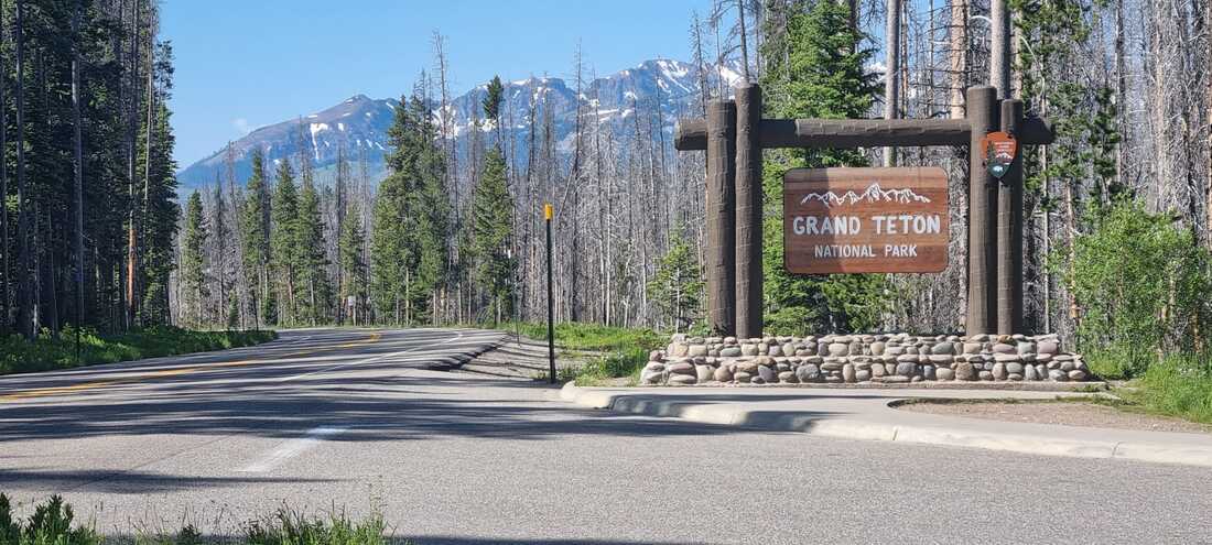
Entering Grand Teton National Park

Wild horses grazzing in the distance

We left Jeffrey City at sunrise to beat the heat and avoid the wind that usually picks up later in the day.
|


The mineral extraction industry (including oil, gas, uranium, coal) is an important employer in Wyoming.


The young Colorado River squeezes through a gorge near Kremmling

We made it! On top of Hoosier pass

Thank you!
|
Rawlings WY - Beulah CO
Crossing Hoosier Pass
Stage 6 is the final one of Phase1. We will cross into Colorful Colorado and fight our last 'battle' with the Rocky Mountains. First crossing Willow Creek Pass at 9621', the trail just goes up and up and up through Silverthorne and Breckenridge.... to finally reach Hoosier Pass at 11542' (3518m), the highest point on the TransAmerica Trail. We are cautiously planning short daily trips to manage the elevation in terms of steep roads as well as oxygen levels. We really hope there isn't any snow left! It is mostly downhill after Hoosier Pass... riding through Fairplay (which is the 'home' of the South Park cartoon series), Hartsel, and Canon City. The famous Royal Gorge Bridge is near Canon City and crosses the gorge 955 feet/291 m above the Arkansas River. We will leave the official TransAmerica Trail shortly before we get to Pueblo and reach the final destination of Phase 1, Beulah, Beulah Valley. (Distance: 369 miles / 594km; Elevation: 14985' / 4567m) 
Beulah is an unincorporated community about 21 miles southwest of Pueblo, in the foothills of the Wet Mountains. The town of Mace's Hole was settled in 1862. The town was named for Juan Maes, a bandit who used the horseshoe-shaped valley for a hideout. The name of the town was changed to Beulah on October 25, 1876. Short trips (by car...) can bring you to famous tourist destinations like Pikes Peak, Bishop Castle or Garden of the Gods.
July 15th, Rawlins - Saratoga: We are in Saratoga tonight. It was only a relatively short ride, but we have to time our rides with available lodging, and not just based on numbers. So we enjoyed an afternoon nap, before we went to the 'Grumpy Italian' for food. We also rode 20 km on the interstate today, because it was simply the only road from Sinclair to the WY130. The thought was kind of scary, but it wasn't bad. The shoulder was wide, and the drivers were very considerate. From here we can see the first snow-capped mountains of Colorado in the distance. We are already at 2070 meters above sealevel, but those mountains are waiting for us! July 16th, Saratoga, WY - Walden, CO: Today, we crossed the state border into Colorado! We were hoping to find more trees for looks and shade! However, the landscape of course takes a while longer to change. Still, we closed in on the snow-covered, rocky slopes of the Colorado mountains in the distance! At first, they appeared far away on the horizon. It's amazing how far we got after a (long) day's ride: one wide valley after the other opened up, and by the end of our day, we were riding alongside these majestic peaks. In a couple of days we will be crossing them! July 17th, Walden - Hot Sulphur Springs: Today, we traveled to Hot Sulphur Springs, and we were back in the forest: The Rout National Forest. The flowing hills of Wyoming were impressive and beautiful. We just like trees. We enjoy the pines and their special smell! Today, we also made it across Willow Creek Pass at 9621 feet / 2932 m. We did reasonably well at that elevation. It felt like a dress rehearsal for Hoosier Pass that we will cross on Thursday. We took a break on top where we met Kristy, a young woman traveling the TransAmerica from West to East. It is always fun to meet fellow travelers and exchange stories, important information about road conditions, lodging, or equipment. You automatically connect, regardless of background or motivation to do the trip. Whether it is the whole TransAmerica, a section, the Great Divide, or just a week on the bike. It is always special! July 18th, Hot Sulphur Springs - Silverthorne: We had two construction stops on the way to Silverthorne. The first one was longer, but well organized for cyclists. The pilot car even had a bike rack on the hitch to hang bikes. It is still a hassle and time consuming to stop, unpack, detach everything from the bikes and the trailer, load everything onto the truck, and after a mile do everything in reverse. The second site just told us to take the dead lane. They were working on a bridge, so the asphalt was intact. We noticed anyway, coming into Colorado, that the roads overall are in worse shape than in any state we had been before. The mountainous terrain and the long winter seem to have taken a heavy toll on the road. We are talking lots of potholes up to 50x80cm and 25 cm deep! That might still work for a truck, but not for a bike. We were not able to avoid all of them, so we had our wheels realigned at a local bike store this afternoon. The bike stores are usually very flexible and accommodating when you mention the Transamerica. We hope the roads get better as we get closer to the bigger or/and more touristy towns in Colorado. Even with all the difficulties we absolutely enjoy the views, the landscape and the experience of cycling and getting higher and higher up the mountains. Silverthorne is next to Breckenridge and not far from such famous ski resorts like Vail or Aspen. The mountains around us now reach 4000m and higher! Our Garmin GPS even told us that we are now adjusted to elevation higher than 2000 meters. July 20th, Silverthorne - Fairplay: We crossed Hoosier Pass today. It was certainly one of the highlights of the whole tour! It's the highest pass of the TransAmerica with 11'539 feet (3517 m). We were kind of apprehensive about the effects of the elevation. However, we started in Silverthorne at a sustainable pace that we planned to keep up for the 50km to the pass. We did feel the thinner air as we climbed, but with some breaks, water and the right pace, we made it and we were fine. It felt great to reach the pass cycling! The view from the top was also amazing. After a short break, we descended through some drizzle to Fairplay. Luckily most of the showers passed to the North of us. In case you don't already know: Fairplay was the 'model' for the famous animation series "South Park". The next weekend, Fairplay also hosts the 'Championship of Burro Racing'. A team of one man and a burro (type of donkey) race over 29 mile/46.7 km and 3000ft/914 m elevation. The price for the fastest couple is $1'000. July 22nd, Canon City - Beulah (HOME): The last two days, we worked hard to reach our final goal for this summer - Beulah. After 3500km and 27500 meter up numerous hills and mountains, we got to the beautiful Beulah Valley halfway through the TransAmerica. Friday, we cycled 120km from Fairplay to Canon City. Very narrow shoulders, road construction, and a few steep climbs, but mostly downhill, through a beautiful landscape and reasonable temperatures. Just to connect with US 50, a major traffic highway artery for the region. For the last 10 miles to Canon City, we were swarmed by trucks, tourist busses, and impatient cars on a multilane highway without a real shoulder. One car's mirror touched Rolf's shoulder at 60 miles per hour, although he had plenty of space to keep his distance. Rolf barely stayed on his bike. After hundreds of miles on roads through less populated areas and even on an interstate, it was a shock to suddenly be in such a situation. We remembered the wide and open roads of Montana or Wyoming, with very few cars and mostly friendly drivers. Today, we knew we would be back to smaller roads, fewer cars, and even some dirt roads on our last stage to Beulah. As we finally approached Beulah, it felt somewhat surreal. We knew these roads, the junctions, and even the buildings! And we were riding our bikes through and around them. Even more exciting was, when 'puffing up the hill to the Beulah Highlands', many of our friends 'jumped' from behind a tree and welcomed us with cheers and a big banner, saying 'Congrats R&C you did it!' What a Welcome! Thanks to everyone who read our blog, contacted us with words of encouragement, and who somehow became a part of this adventure! Thanks also to all the cyclists who we crossed or met for their 'Safe Travels' or the exchange of stories. They made us feel part of something bigger than our own story! |


