Intro: If you wonder about the choice of route, phase and schedule, please read more about the 'How?' on the 'Home'-page.
As we progress, we will add 'trail-pictures' and will add travel blogs with stories and our travel experience.
As we progress, we will add 'trail-pictures' and will add travel blogs with stories and our travel experience.
Mission Complete @ Dares Beach, Maryland!
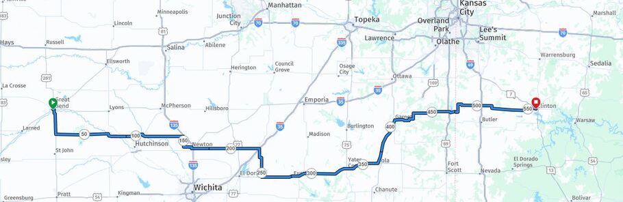
Stage 1: Beulah CO - Great Bend KS (563km)

|
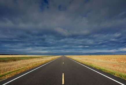
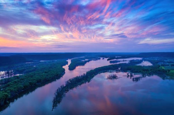
Leaving the Rockies
Stage 1 - We are leaving the Wet Mountains and Beulah behind us and ride into the city of Pueblo, past Lake Pueblo, an artificial lake that provides a great local recreational area for wildlife and people. We cross the Arkansas river and head east towards the endless horizon of Eastern Colorado and Kansas (we cross into Kansas after Sheridan Lake). There are no passes but pretty level terrain with open roads. No trees and never-ending fields of wheat, corn and grass. Will we have great tailwinds, or if it will be a battle with headwinds? However... we are back on the road again! (Distance: 358 miles / 563 km; Up: 2'275ft / Down 6'625ft) Our Travel-Blog
May 2nd 2026 Beulah - Ordway
This morning we left Beulah behind us. Just yesterday it had snowed and the weather forecast for today was promising. Some of our friends said goodbye to the crazy people. It was not easy to leave a safe home, but the East Coast was not going to move to the west... We knew the road to Pueblo really well, and we also knew our way around Pueblo, but as soon as we left Pueblo to the east it was all new. After the green hills and mountains of Beulah, the area East of Pueblo just became flat and mostly brown at this time of the year. We followed the 96 east and it pretty much all looked the same. The little towns with 300+ inhabitants have a post office, a small city park with a covered area and often a small general store, not much else. The 96 also runs parallel to the railway, so we got to see really long trains, with up to 5 locomotives pulling the same train. We took a couple of breaks but made it to Ordway shortly after 4pm. 127km! It was the longest daily ride for the whole trip. We intentionally wanted to see if we would be up to it, and we think we are! May 3rd Ordway - Eads
Today, we continued through Eastern Colorado, still along the train tracks. After a cow farm. The plain got even wider, with a lot of brown grass, always some birds, but not much else, not even a single train! The cows of that farm were so funny: there were dirt mounds spread out in their field, and from far you could see the silhouettes of single cows on top of these mounds! We were still a bit sore from yesterday, so we had a break after 20 miles, in Arlington, under some beautiful Cottonwood trees. Arlington consists of one single old farm with two barking dogs. The plains are so wide open and empty! You can see the next place from far ahead. Most of the time you see an old grain silo against the horizon, but you know it's going to take another 30 minutes to get there. There are the tiniest towns (like Haswell, pop. 65). They have a city park with covered picnic benches and a relatively large playground. As we got closer to Eads, our destination for the day, green fields became more frequent, possibly with winter wheat. Most of the huge silos are right next to the train tracks. The wheat is loaded directly onto the train. We had winds from all directions during the day. We definitely don't like strong headwinds. Especially on a landscape like this, there is nothing stopping the wind. But we managed. Some forecasts call for a change in the weather... cold, rainy, and even snow. We will decide on Monday night if we need to hunker down in a warm motel room... May 4th Eads, CO - Tribune, KS
Today was more of the same regarding the landscape. We did not expect any change when we finally reached Kansas... However, the road, that had become really bumpy for the last 30 kilometers, got much better the moment we crossed the state line! Kansas seems to have more money to maintain the roads. We will stay the night in Tribune, KS. We were even early for check-in because Greeley County (Tribune) is in Kansas but still belongs to the mountain time zone, while the rest of Kansas is at Central Time (+1 hour). Today the weather was mostly sunny and almost 30°C. Tomorrow there is supposed to be a high of 9°C max, and the next day a high of 5°C max... We will decide tomorrow morning whether to stay here for a couple of days in a warm place or at least make it to Scott City. May 5th Tribune - Scott City
Today, the conditions were tough: temperatures around 6/7° C (45° F), constant headwinds between 15 and 25 km/h, and even rain in the afternoon! And we had our first flat tire. A piece of wire had worked itself into the tire of the trailer. We replaced the tube on the side of the road, without freezing our fingers off. We had all the tools and parts. We had lunch in a warm restaurant at Leoti, and now at the end of the day, we got to a warm place in Scott City safely. Tomorrow will be even colder, with the possibility of snow. We'll just stay here and have our first break day a bit earlier than planned! The local people are glad for the precipitation, so we can take it. As we drove deeper into Kansas, the farms with these huge fields are mostly well taken care of, and the houses look nicer! We saw some houses that were built lower, up to their windows in the ground! Probably because of the wind and insulation. May 6th Rest Day in Scott City
We decided to stay in Scott City. Read, shop for groceries, plan the next days, fix the damaged tube to have a spare again, etc. Tomorrow we are back on the bike! The weather forecast is much better! 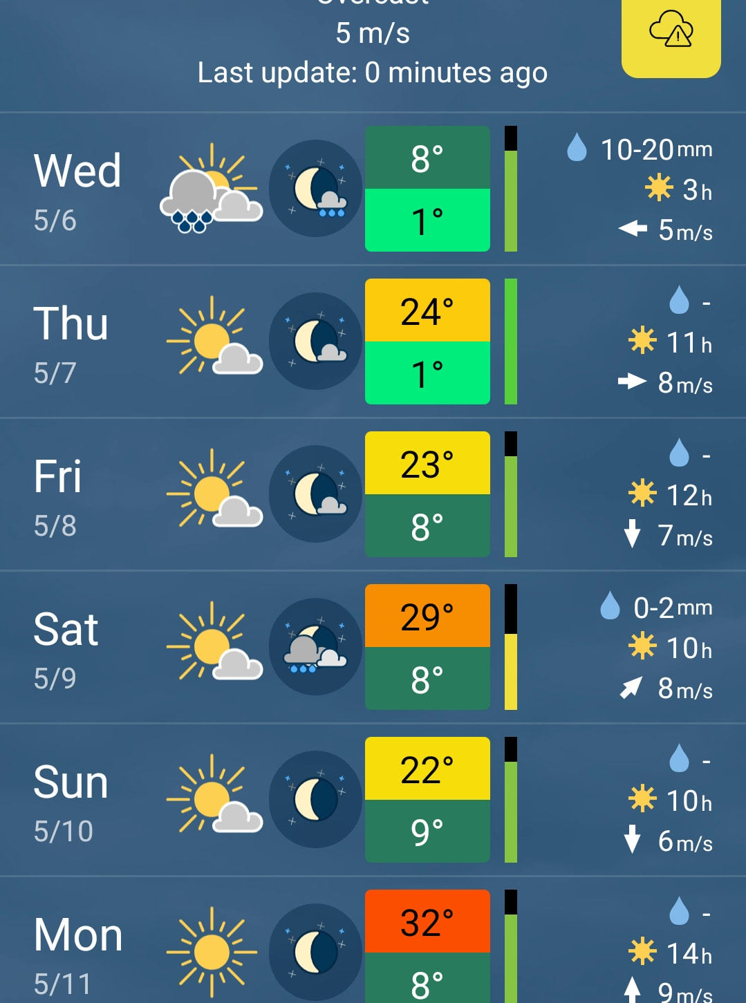
May 7th Scott City - Ness City
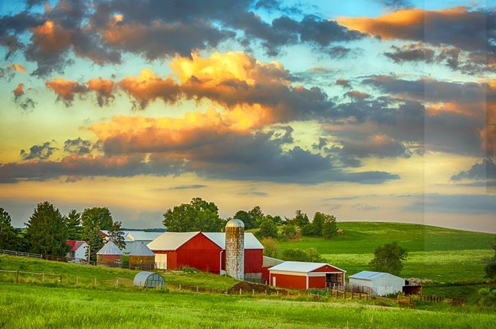
Weatherwise, it was almost the perfect day! Nothing like a couple of days ago: Nice tailwind, 10C in the morning, 20C in the afternoon! So we arrived earlier than expected in Ness City, our next stop after about 90km. Ness City doesn't have a motel, and camping would have been 3-4C at night, so we booked an Airbnb. A whole house just for us, including a garage for the bicycles. So instead of eating at a restaurant, we got a healthy meal from our own kitchen. We noticed on the way that the farms got nicer and the towns got cleaner. A lot of houses have several rows of trees and bushes to protect them from the wind. We spent some time at the city park as we were waiting for check-in time, and talked to people. People around here live almost exclusively from and with farming. One lady has a farm with 10 thousand acres (40 km²!). They grow sorghum and wheat. They have cows and even pump a few barrels of oil on their property. It's a lot of work, but it provides for two families. The average farm only has about 5000 acres. What would a Swiss farmer do with 20 km²...? May 8th Ness City - Great Bend
Today, after 7 days cycling, we finished our first leg out of 6 to the East Coast! It was about 600 km (350 mi). We had to work hard for it though! There was a lot of headwind, and for the last third the rumble strip was right in the middle of the shoulder! Try to ride a bike on it! You're not going to last 10 seconds! So we rode on the street, and most cars/trucks are very polite and changed lanes! All day the route took us alongside Walnut Creek, which actually carried some water! You could always see its location because it is framed with fresh green-leafy trees! We met some cyclists today, and exchanged experiences on bikes and bike routes. These are interesting people! All enjoy the independence on the road! One was from South Korea. He has been cycling in Asia a couple of times, and this is his first time in the USA. In Korea, people aged 40 and older like to cycle, but it's not in fashion for the younger ones. We will continue our blog further down for section 2. |
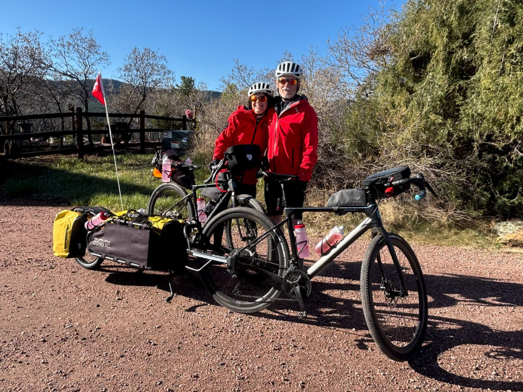
Ready for the ride
|
Our Travel Pictures!
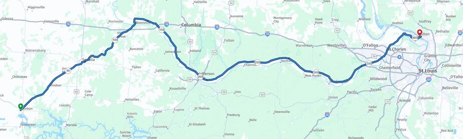
Stage 2: Great Bend KS - Clinton MO (558km)
|
The Open Roads of Kansas
Stage 2 - We ride the open roads of Kansas through lots of small towns, still along Section 7 of the official TransAmerica Bike Trail, rolling pretty parallel to US Highway 50 and straight east. We leave the TransAmerica trail and get onto the 'TransAmerica Connector' near Toronto Lake and head northeast towards Clinton MO, but stay south of Kansas City. We cross into the State of Missouri shortly after the town of LaCygne. We decided to leave the TransAmerica to use more of the Rail-to-Trail network like the KATY Trail further north. Most of the Rail-to-Trail trails were not yet available when the original TransAmerica was set up. (Distance 347 miles / 558 km; Up: 4'925ft / Down: 5'975ft) Our Travel-Blog
May 9th Great Bend - Hutchinson
Today's ride led us to Hutchinson, KS. The original route would have ended in Nickerson, but we couldn't find any place to stay for the night. There was no city park with toilets, and thunderstorms were in the forecast. Hutchinson is a larger city 10 miles south of Nickerson. Almost all day, we rode off the main road through a wildlife refuge with ponds, lots of trees, and reeds. Virtually no traffic, so we could usually ride side by side, discussing what we saw and 'everything else' life has to offer. It was also hotter than previous days with 30°C+, but it was OK, not humid. For those Swiss who can't imagine how big Kansas is: Kansas is about 5 times the size of Switzerland, with about 650 km to cross Kansas from west to east. So currently we feel like ants crawling across this huge and open state at about 100 km per day. ❤️ Happy Mother's Day Mom! 🪻🌸🌻❤️
Your Children and Grandchildren May 10th Hutchinson - Newton
We left kind of late because of rain storms. At 3pm we got to the beautiful little town of Newton. It wasn't a very long distance, 60 km (37 mi), but we had headwinds pretty much all the time. Luckily, they grow these long, narrow and dens rows of trees (about 5-10 m wide) in between fields and sometimes alongside the roads. Newton is beautifully situated on the Sand Creek: There are walkways on both sides of the creek with benches and a big park! It carries a lot more water than the Arkansas River, which we have been crossing once in a while since Pueblo! As a comparison for the Swiss: the Arkansas River here has a little more water than the "Pfaffnere", while the Sand Creek is about the size of the"Emme". May 11th Newton - Eureka
It was a long day today: we did 120 km (78 mi) and had headwinds for about half of it. I think we are ready for a break! But we are going to check the weather first. In the morning, the landscape was really beautiful: very green with lakes and creeks! Later, it was more cowboy land: a lot of huge, rolling pastures - without trees, with big herds of Angus cattle. There were a lot of young calves, that liked to either run away as we cycled past, or chase us! May 12th Eureka - Iola
Another day in the saddle... We made it to Iola, still in Kansas, after a total of about 1000 km on the road! We had a couple of special moments! We saved a turtle that was trying to cross a major highway from being run over by one of the many cars or trucks. We bravely fought pretty bad crosswinds of 30-40 km/h that tried to push us into traffic. At times we were leaning into the wind, just to ride straight, and in Yates Center, where we had lunch, we met a few ladies who wanted to know what we were doing. They decided that we should hold hands. They prayed for us and asked God to bless us and our travels. It was very genuine and personal. May 13th Rest Day in Iola We are resting and recovering for the next stages. May 14th Iola - La Cygne
Today, we cycled for the first time on one of these many rail-to-trail trails, the Prairie Spirit Trail. It was a beautiful trail between trees! No traffic, no wind, and no sun - it wasn't shining a lot anyway 😉. It was a dirt surface, so it took some more effort, but you can't have it all, right? At Garnet, about halfway, we turned East, off this trail onto side roads towards La Cygne. These winds were crazy! And part of the route was a rough dirt road, where we had to cycle pretty slowly. So we treated ourselves to a really big meal in a sports bar & grill. For Swiss people: it's the kind of place you see in a movie, with a dark interior, Budweiser neon signs, a stage, and an Honor Wall for all the fallen local heroes. May 15th La Cygne KS - Clinton MO
Today was a special day in many ways. It was the last day of stage 2! We are definitely leaving Kansas, it's getting hilly and wetter, and we met an old friend for dinner. There was a lot less wind today, but shortly after crossing the state line into Missouri, the roads began to change! A constant up and down, from lowest gear to highest, and back again. It was almost as exhausting as riding into constant headwinds. So in the evening we ended up climbing 800 meters and almost at the same elevation as in the morning. We finally made it to Clinton, the beginning of the KATY Trail, where we met Christy. We met during phase 1 of our TransAmerica, somewhere on a pass, as we were fighting mosquitoes, and she helped us with a bug spray. We have stayed in touch, and she even visited us in Switzerland when she was cycling in Europe! Her sister lives in Kansas City, and so she decided to visit her sister and us from Minneapolis. |
Our Travel Pictures!
Stage 3: Clinton MO - Alton IL (415km)
|
The KATY Trail
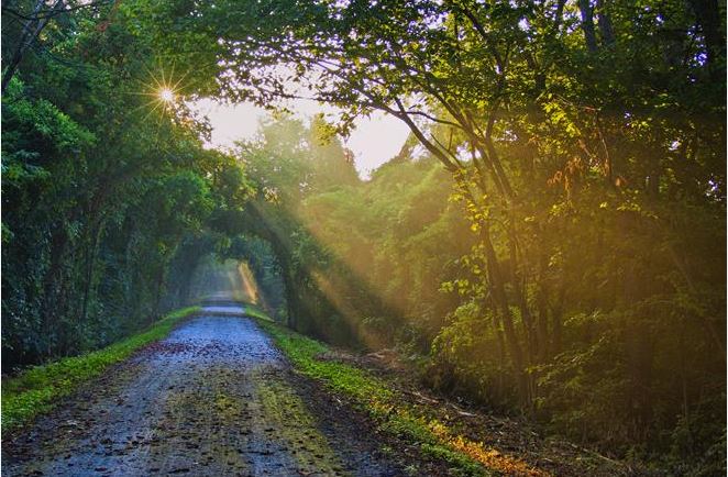
Stage 3 - In Clinton MO we get onto the famous KATY Trail (Missouri-Kansas-Texas Railroad - MKT = KATY). With about 240miles /385km, it is the longest established Rail Trail in the US. That means NO traffic but hikers and fellow cyclists for several days. It means very moderate grade and lots of trees along the trail. However, it also means no paved road and possible floodings as we will follow the Missouri river. Of course we hope for the best and accept the rest. The KATY trail ends in Machens near St. Charles and a few miles from the Mississippi river. (Distance: 254 miles / 415km; Up: 2'825ft / Down: 3'150ft) Our Daily Travel-Blog
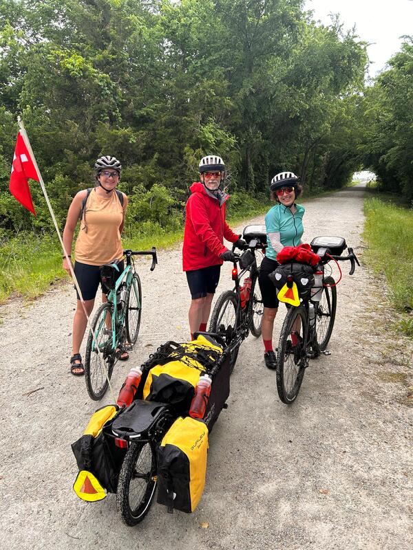
We had met Kristy years ago during phase 1 and she visited us in Switzerland. We met for dinner in Clinton and she joined us for the first 30 kilometers of today's trip. She is definitely a world cyclist!
May 16th Clinton - Boonville
Today, we crossed the Missouri River! That's a huge milestone for us. We came all the way from the Rockies through the prairie! It was a long day today: 130 km (83 mi) exclusively on gravel! It was a nice ride, too: all on the KATY Trail: a lot of shade under the trees, a pretty even gravel road (a bit soft at places from the rain at night), gentle ups and downs, and a lot of wild animals: squirrels, rabbits, birds, especially the red cardinals and some really shiny blue ones! We also saw more turtles including big ones, and finally an opossum that just looked at us, saying, "That's my trail, just so you know!" May 17th Boonville - Jefferson City
We made it to Jefferson City today. The whole route was once again on the KATY Trail until we reached Jefferson City, the capital of Missouri, where we had to get across the river to get into the city. We met a number of cyclists, families, young and old, who were riding at least a part of the KATY Trail on a Sunday or were doing the whole trail as a week's vacation. The Missouri River is pretty wide in this region, and according to an older gentleman, always pretty brown from all the sediment (loam). We had some thunderstorms last night while camping, so we left kind of late, and were already tired because we didn't get too much sleep. However, we made it and decided to take a day off tomorrow, especially with more storms and high winds coming. May 18th Jefferson City Rest Day We are taking a day off. The weather is really awful! 
May 19th Jefferson City - Marthasville
Yesterday, on our day off, the weather was stormy and it had rained a lot. Consequently, the fields next to the trail were partially underwater, the creeks that flow into the Missouri River were full of muddy brown water, and often, the forest next to us was swampy. At one spot, we had to pedal through about 20 cm of water. At first, we had no idea how deep it was going to be! Because of the storms, a lot of trees had fallen across our trail! Luckily, it's relatively easy to unhook the trailer, and so we lifted our bikes across. The trailer is just bulky to carry over the branches. We met quite a few cyclists doing the KATY Trail. We even pedaled for some distance with a lady from Wisconsin and chatted about her dairy farm. May 20th Marthasville MO - Alton IL
Today, we completed the last leg of 110 km (68 mi) on the KATY trail. The KATY was a lot tougher than we expected. The heavy rains softened the surface so much that riding on it took much more energy than riding on asphalt or a hard-packed dirt surface. Today, we also completed 1600 km or 1000 miles since we started phase 2 in Beulah. In Europe, that would be like starting in Vordemwald, going all the way up north to Gothenburg, Sweden! Today, we also crossed the Mississippi into Illinois! It now really feels like we are halfway from the Rockies to the Atlantic! |
|
Our Travel Pictures!
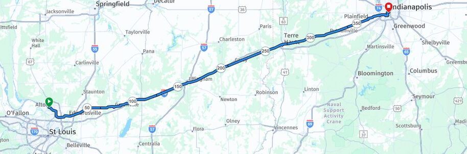
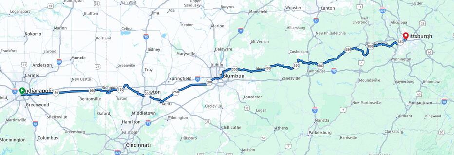
Alton IL - Indianapolis IN (430km)

|
Crossing the Mississippi River
Stage 4 - Right at the end of the KATY Trail, near St. Charles, we cross the mighty Mississippi into Alton, Illinois. We are definitely no longer in the Western United States. We will pass St. Louis to the north and work our way around the city. Unfortunately we no longer have a rail-to trail to follow, but standard roads until we reach Indianapolis. We are now officially on the 'Eastern Connector' of the Adventure Cycling Association's trail system. This connector is part of a speedier coast-to-coast trail than the TransAmerica. It connects the western part of the Transamerica Trail from Colorado with the 'Chicago to New York' Route. We will follow that connector to Indianapolis. (Distance: 266 miles / 430 km; Up: 4'900ft / Down: 4'675ft) Our Travel-Blog
May 21st Alton - Greenville
Today, we first cycled alongside the confluence of these two giants, the Mississippi and Missouri Rivers. We watched as big engine boats slowly maneuvered big, heavy barges up and down the rivers. Then we turned east through Edwardsville with its pretty and fancy houses. From there, we drove on another one of these rail-to-trail trails. As a local told us, now there are more of these former railway lines being developed, especially close to cities. They are some of the only places, where people can exercise outdoors. It's not like in Switzerland, where the forests have a lot of public trails. May 22nd Greenville - Effingham
We drove 85 km (53 mi) through rural Illinois today. There are quite a few little towns, somewhat bigger and more frequent than in Missouri or Kansas. But in contrast, the farms seem smaller, both in their buildings and fields. It got a bit colder during the day, so we had to put on more layers of clothing, especially during our lunch & nap at a Veterans park and later in the afternoon. It was overcast, and we got some sprinkles towards the end. The wind was blowing straight at us from the east / northeast again, though after lunch all the way to Effingham it eased up a bit. May 23rd Effingham IL - Terre Haute IN
Today, we did 118 km (61 mi) and reached our Airbnb in Terre Haute, Indiana! It's the 5th state since we started Phase 2! The US is known for its superlatives, right? We found some cool ones in Casey: the world's longest pencil, the largest mailbox, the largest rocking chair, and the largest wind chimes! They had a really deep sound! There were actually quite a lot of tourists in little Casey looking at these attractions. The town looked very nice, with lots of flags for Memorial Day. We actually saw a lot of nice and clean little towns along our route through rural Illinois today. In Casey they also sold a tasty pretzel baked with cheese, ham, and pineapple! May 24th-25th Resting and Planning in Terre Haute IN
Today and tomorrow, we are staying at Terre Haute and let our legs and our heads rest. We also review the second part of our trip including the exact route, lodging, breaks, etc. Terre Haute has about 60'000 inhabitants and sits above the Wabash River. That's what it got its name from: it was founded by the French who came north along the Mississippi, then followed its tributary, the Ohio River, and looked for a route north to the Great Lakes and Canada. They found the Wabash River, which would later be connected to Lake Erie by the Erie-Wabash Canal. This canal was built after 1850 and it’s the longest ever built in the USA, 740 km (460 mi) long! A lot of trappers and traders used this route. The city was named "elevated land" since it sits safely above the river, protected from flooding. Later on our ride, we will also cross the Ohio River a couple of times. May 26th Terre Haute - Plainfield
Today, we continued east until Plainfield, on the outskirts of Indianapolis. We mostly followed the National Historic Road, today's US 40. It was the first federally funded highway, authorized by President Thomas Jefferson in 1806. It's also called "the road that built America" because thousands of settlers could now travel more easily through the mountains to the rich lands of the Ohio River. The landscape is really lush and green. The trees are very tall! We gained about 120 m in elevation, but climbed 460 m with all the ups and downs! We had some headwinds, and, at the end, Cornelia got a flat. Luckily, the tire was slowly deflating, and we safely got to the hotel, where Rolf repaired it. May 27th Plainfield - Indianapolis - Greenfield
Phew! We got really soaked today! Luckily it was a short day: 80 km (50 mi). We rode from Plainfield through Indianapolis to Greenfield, our goal for today. It poured heavily from Indianapolis onward! Once we were wet, we just kept going for the last 2 hours and kept warm by pedaling. Water dripping from our helmets constantly tried to turn off the navigation on the Garmin. After we arrived and got dry, we went to a local bike store to replace the pedals on Rolf's bike. The left pedal's axle didn't rotate properly and kept getting stuck. Mitch installed a new set. He even asked us if he could take a picture for the store's social media. There were quite a few bike paths in and around Indianapolis. Some are really nice! But one 2-mile stretch along the White River in Indianapolis was really unpleasant, even unsafe in places. The homeless had established camps along the trail with tons of trash, fires, sheds, tents, etc. Maybe that's the downside of a big city, but it's still something we don't understand. Indianapolis is the third biggest city in the Midwest, after Columbus and Chicago. The blog continues in the next section. |
Our Travel Pictures!
Stage 5: Indianapolis IN - Pittsburgh PA (662km)
|
The Home of Bike Touring and Flight
Stage 5 - This stage leads us through three states and a region with numerous bicycle trails. Particularly Ohio is a state where you could bounce around dozens of trails all summer long. Ohio is where the famous Wright Brothers had a bicycle store (Dayton) when they developed their 'flying machines' and flew them in North Carolina. Ohio is also the home of Charlie Pace, who was one of the 'founders' of the Bikecentennial in the 70s and later the Adventure Cycling Association. We are also looking forward to the wooded regions of Pennsylvania before we reach Pittsburgh. (411 miles / 662 km; Up: 14'325ft / Down: 14'200ft) Our Travel-Blog
May 28th Greenfield - Richmond
Today, we had a great day with blue skies and only a little headwind! We did 88 km (58 mi), mostly on Road 40 to Richmond. We found out that, because the weather was nice, it was the day that people on Road 40 had their yearly yard sale! For the Swiss: people clear out their garage and sort out their stuff. In the USA, most families don't have a basement or attic, so everything ends up in the garage. So, what they don't use anymore, they put out on the front yard and they write a sign with "Yard sale". Usually the neighbors stop by and buy things they can use at a good price. Today, however, was something bigger. Along the whole US 40 in Indiana (200+ km) there were hundreds, if not thousands, of tables, booths, etc. This event, the week after Memorial Day, is well known and people from far away drive by, park their car on the side of the road, and hunt for great deals! It was sometimes not easy to avoid all the parked cars, but it was fun to watch. Rolf called it the country's largest "junk relocation event". May 29th Greenfield IN - Dayton OH - Beavercreek OH
We got to Ohio basically as we left the last hotel and continued eastward. Ohio is many things, but the Wright Brothers are certainly among Ohio’s most famous sons! Well, we rode only about 80 km (50 mi) and for a change we had perfect weather. First, we still had 20 mi on US 40, but then we got onto a great bike trail along the Wolf Creek and then along the Miami River in Dayton. Altogether, that was 30 miles of trail! It wasn't always perfect, though. Next to the Miami River in Dayton, the trail was partially submerged by high waters, so we had to find alternatives. It's not really our favorite to navigate through big city streets: It's slow and tedious going! Closer to Beavercreek, where we are spending the night, we passed the Air Force Museum: this museum is supposed to have the best collection right after the Smithsonian! A local cyclist we got to talk to told us all about its highlights, from the Space Shuttle simulator to the actual Bockscar (plane that dropped the nuclear bomb on Nagasaki). For the Swiss readers: this location makes sense: It's where the Wright Brothers invented and built the first motorized and steerable airplanes at the beginning of the 20th century, before flying them on the beach and around the fields of North Carolina. May 30st Beavercreek - Grove City (Columbus)
We had an interesting ride (104 km/64 mi) to a southwest suburb of Columbus (Grove City). Our route took us almost completely on beautiful bike trails. We're also glad about the protection of the trees, because at times the headwinds were pretty strong! At our first small break, we happened to stop at a "Disc Golf Course". We had never seen one, but it's pretty cool! It's like a shorter golf course but with frisbees! We got to talk and watch some guys doing it. It was a real challenge to aim between huge trees towards the "T-basket" and across the creek! Sure enough, it got stuck in the branches and then fell into the creek! These guys were not shy to take off their shoes, wade into the water, and fish it out with some extendable "pliers"! They also had about 20 discs each on a cart, similar to a golf cart. Apparently, they use different discs depending on the distance. They were a fun group to chat with!! Since we rode on bike trails, there were a lot of other cyclists! We got to chat with a couple from Dayton and kept riding with them for about 20 miles! We had a lot of interesting topics to talk about, so they invited us into a very cool local coffee shop! Their kids had left for college and so they were finding new things to do, among them riding their bikes on a Saturday morning 😀. You can't plan for those types of 'meetings'. We'll be staying at an Airbnb for the next two nights. We need to do laundry and take a short break. June 1st Grove City - Heath
We had a shorter day today with 70 km / 44 mi to Heath, close to Newark. A big part was through traffic around Columbus. Cornelia had planned a way with Google Maps for bikes (!), but traffic got heavier and heavier and the shoulder smaller! We found ourselves in 5-lane traffic with semis, dump trucks, and cars. Finally, the police stopped us and kindly but firmly told us to get off the freeway and onto side streets! 😬 Well, we safely got to the other side of town and had a lunch break at a historic marker on our well-known Road 40! That's when a mom with her two boys stopped to show the boys the markers. They were planning to walk the two miles from this marker to the next historic "mile-marker pillar". We had a great chat with them! They enjoyed it too, and we're meeting them for dinner tonight to continue the conversation, including the dad, who is a history teacher! June 2nd Heath - Cambridge (OH)
Today was less eventful, but tough. It started easy with a nice bike trail out of Heath and Newark. The surface was hard, and there were no major hills. It all changed when we had to leave the trail. We got three out of four biker hells. The weather was warm but nice. However, the road turned into a roller-coaster, the shoulder was non-existent or consisted of a rumble strip with endless huge potholes (we are talking 60 cm in diameter and 30 cm deep!), and 30-40 km/h headwinds. Our remedy for these atrocities: We stopped for ice cream! We still ended up in Cambridge really tired, and with a relatively low average speed, but happier than without the ice cream. June 3rd Cambridge OH - Wheeling WV
We made it to Wheeling, West Virginia! We suspected it would be a hard one, and it definitely was! It was 95 km (58 mi) across a very hilly route, which added up to 1000 m in altitude gain! The landscape is really pretty: little towns and farmland nestled between wood-covered slopes, almost like Switzerland! A lot of farmers were collecting their hay. For the first 10 miles, we rode an easy-rolling, wonderful trail: the Guernsey Trail. It had cute boards with children's activities and we were passing by pretty bird ponds. For the rest of the day, it was up-down-up. Some sections were well over 10% steep and we really got very close to our limit... but only close! And then just outside Wheeling, we were discussing the best route to the Airbnb, when a man walked up to us with two bottles of cold water and offers us a drink because it is hot and we look tired! Thank you! June 4th Wheeling WV - Pittsburgh PA
We made it to Pittsburgh!! It was 115 km (73 mi) and 500 m in altitude gain. We were glad that much of the rout was on trails since they cut through some of the hills, as they were former rail tracks! After a long climb, we had a really good ice cream at a small coffee shop. It was like a meeting place for retirees, kids on summer break, and cyclists riding from the east or west! Suddenly there was Pittsburgh right in front of us! It is a really impressive skyline between these two rivers, that then join to form the Ohio River! |
|
Our Travel Pictures!
Stage 6: Pittsburgh PA - Chesapeake Beach MD (620km)

|
Crossing the Appalachian to the East Coast
Stage 6 - The last stage will lead us from Pittsburgh through the Great Allegheny Passage, a bike trail that was originally a train track between Pittsburgh and Cumberland, that crosses the first part of the Appalachian Mountains, the mountain range more or less parallel to the East coast. After Cumberland, the bike trail continues directly onto the Chesapeake and Ohio Canal (C&O Canal), an artificial waterway with 74 locks that was built between 1828 and 1850 to transport goods (mostly coal) between the Allegheny Mountains and the east coast. The canal ends at Washington D.C. From there we head to Waldorf and then to Chesapeake Beach to reach the Atlantic waters. (Distance: 390 / 620km; Up: ~16'325ft / Down: ~17'125) Our Travel-Blog
June 6th Pittsburgh - Connellsville
We just made it to Connellsville, PA (89 km, 51 mi) before we got a tornado warning and witnessed a pretty bad storm and now the whole town is blacked out. Lots of trees down. A small food truck with a generator is just making a killing in sales! We are staying at a "hotel", which is a very special old house. It probably was a hotel 120 years ago! It has statues in front of the house and inside it's richly decorated with famous pictures, crystal chandeliers, heavy furniture, and curtains with crystals! It was our first day on the GAP: the Great Allegheny Passage through the Appalachian Mountains. It was a beautiful day and a Saturday, so we saw and talked to a lot of people enjoying the trail by bike or boating down the Youghiogheny River. They had a lot of fun! We had an ice cream at an art shop. The lady made special jewelry and wall decorations with mosaics out of natural stones, that she shaped herself with a hammer on an anvil with a ridge. She actually showed it right when we were there! June 7th Connellsville - Meyersdale
We rode our second day on the GAP for 95 km / 57 mi to Meyersdale today. Almost the entire route was in the forest next to the river. We could see where we were in relation to the surrounding villages when we crossed the river or rode across a huge viaduct, but otherwise it was like a green, cool, and shady tunnel! During last night's storm, a lot of big trees had fallen across the trail and scattered branches that we constantly had to avoid. There were some really nice people who helped us carry our trailer across big trunks! One of those really long black branches suddenly moved, and we could evade it at the last second! It was a 6-foot black snake! We later learned that it wasn't dangerous to humans, but it scared us anyway. The whole trail gradually climbs toward the eastern continental divide that determines whether the rivers drain to the Mississippi basin or the Atlantic Ocean. At Meyersdale, we are only a few miles from that divide. Once we reach that highest point, we can roll downhill to the ocean. We know it will not be that easy, but it feels good to think about it. June 9th Meyersdale PA - Oldtown MD
We got to the Eastern Continental Divide, 729 m / 2392 ft above sea level, the highest point since crossing the Mississippi! From here, the water either drains west into the Mississippi basin and into the Gulf of Mexico/America, or east into the Atlantic. After riding 96 km / 60 mi gently downhill, we are now at 171 m / 561 ft above sea level, our lowest point since crossing the Mississippi! After all, we are getting closer to the ocean! After Cumberland, we got onto another trail: the C&O Canal Towpath, the Chesapeake & Ohio Trail. It's the former towpath (the mules towed the boats) for the canal next to the Potomac River between Cumberland and Washington DC. It was built in 1831 and was used until 1924 to transport primarily coal. For the people living out here now, it is just very pretty to go hiking, biking, or jogging. There are, however, not too many job opportunities outside of tourism! June 10th Oldtown - Williamsport
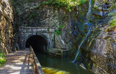
We continued on the C&O Canal Towpath for 97 km / 58 mi to Williamsport. We went through the Paw Paw tunnel. A Paw Paw is not a nickname for a friendly dog. It is an indigenous nickname for a fruit native only to some parts of North America. It bruises very easily, which makes it very difficult to trade, and it tastes like a mix between a peach and a mango. It's best eaten right off the tree. It had rained last night, so the trail was muddy and there were a lot of puddles and mud holes to plow through. You can imagine what our backs and our bikes looked like! I am sure each bike was 2.5 kg / 5 pounds heavier in the evening than in the morning! We were a bit afraid the thunderstorms would catch up with us, so we took shelter as a precaution at Fort Frederick State Park. But the storm dissipated, and we had a good long break anyway. They also had a water pump, so we could rinse the worst of the muck off the bikes, an act we had to repeat when we got to our hotel. The landscape in this part of Maryland is now much flatter and civilization starts to take over bigger areas again! We are less than 100 miles from Washington DC! June 11th Williamsport - Brunswick
Phew! It was warm today, 35°C / 95°F, and muggy! Luckily, it was mostly under the trees, but the water just kept dripping off our faces! We got to Brunswick after 80 km / 50 miles, so it wasn't so far. Tomorrow's ride to Washington DC will be longer and will still be hot. We will just keep pouring water into our bodies! It was a pretty ride, especially the rapids around Harpers Ferry! George Washington actually founded the company to build a canal around those rapids and waterfalls to improve transportation on the Potomac River. Even today, you can still tell where this original canal helped to get past the rapids. We also met a guy who approached us with the question, "Are you the Swiss?" His buddy had met us in Kansas and had told him that we were going to ride on this trail around this time. We certainly learned that cyclists are a bit of a special breed in the US - they share lots of information about trail conditions, good lodging, good places to get food, etc. There is a strong spirit of mutual support among cyclists. The guy we met today is just one example of that. June 12th
❤️ Happy Birthday Dad! 🎂🎉🚴♂️🎈❤️Your Children and Grandchildren Brunswick MD - Washington DC
Today we got to Georgetown in Washington DC! We did about 90 km / 57 mi in the blistering heat! The temperature reached 38°C / 100°F, if you include the moisture factor it felt like 42°C / 110°F! And yes, we drank a lot, and left earlier than usual, but it was just really too hot all day. The Potomac grew even wider. Also in contrast, the Great Falls, where the river is forced to go through a gorge and down rapids, were especially impressive! Cyclists are so easy to talk to even if you don't know them. Christy, a US friend from Minneapolis, had told us that friends of hers were doing the same trail but in the other direction. She told both groups how to recognize each other. And sure enough, we met each other and had a great chat! Their son is a professional gravel-bike racer and he has also raced in Switzerland, and they had done several bike tours in Europe! So we had lots to talk about even though we had just met. Traffic in Washington was crazy! As soon as we got off the trail, the streets were full of cars and all of them, it seemed, were honking! We fortunately found a single trail shortcut that helped us to avoid the angry car owners. It was perilously steep, across rocks and roots, but by now we are professional at crossing obstacles! June 13th Washington DC Rest Day
Mayhem in the city! Today was our Washington DC day, with museums and monuments. However, first we had to get where we wanted to go. The bus ride was uneventful, but as soon as we were getting anywhere near the White House or the big monuments, we ran into blocked streets, National Guard, and police. For several blocks of downtown, no vehicles or pedestrians were allowed. Obviously this was a perfect storm: A UFC fight on the White House lawn, a huge fan zone for the soccer World Cup games, and thousands of tourists that had descended (not our words) on the city to celebrate the country's 250th anniversary with all its events. In the middle of it all, there were two Swiss who had become used to squirrels, deer, gravel, and small-town USA. Of course we adapted and went through our touristy checklists and drank lots of fluids, because it was still pretty hot. All in all a good and interesting day, but we won't mind riding on our bicycles again tomorrow. We hope early Sunday morning will be more quiet and have fewer blocked streets, as we have to ride to the other side of the city. June 14th Washington DC - Waldorf MD
It's our second last day! We didn't know what to expect riding through Washington DC and out of it. So, we had only planned a ride of 60 km / 38 mi from Georgetown to Waldorf, Maryland. We found a way through Washington without hitting too much traffic and without getting in trouble. First we got back on the C&O, followed the Potomac for quite a while, and connected to the Mt. Vernon Trail. In the distance, we saw all the monuments and the government buildings we visited yesterday. This morning we actually rode in DC, Maryland, and even Virginia. We crossed the river on the Woodrow Wilson Memorial Bridge and then rode through nice neighborhoods over rolling hills until we had a quick scare, because we thought we were on a major highway again! But it had a wide shoulder. We felt safe. We're also excited about tomorrow! We're going to head to the Chesapeake Bay and dip our front wheel in the Atlantic Ocean! June 15th Waldorf - Dares Beach @ Chesapeake Bay!
We made it!!! Our last 'acrossamerica.bike' adventure led us from Waldorf to Dares Beach on the Chesapeake Bay (and back). We rode mostly on busy roads with multiple lanes but with nice wide shoulders. The closer we got to the beach, the less traffic we had. The access to the beach was restricted to residents of the beach community. However, after we rang the doorbell of the house next to the beach and nobody answered, we went around the chain and did what we had come to do: dip the front wheels of our bicycles in the Atlantic Ocean! A truly magical moment, we celebrated between the two of us, even without spectators or fanfare! We had invested a lot of time and energy to get there! Against all odds! This is our last blog entry. This chapter has been written. We will keep the website going for a while before we shut it down. However, those of you who have known us for years know... new ideas will soon see the light of day. 😉 |
Our Travel Pictures!

